Newsletters
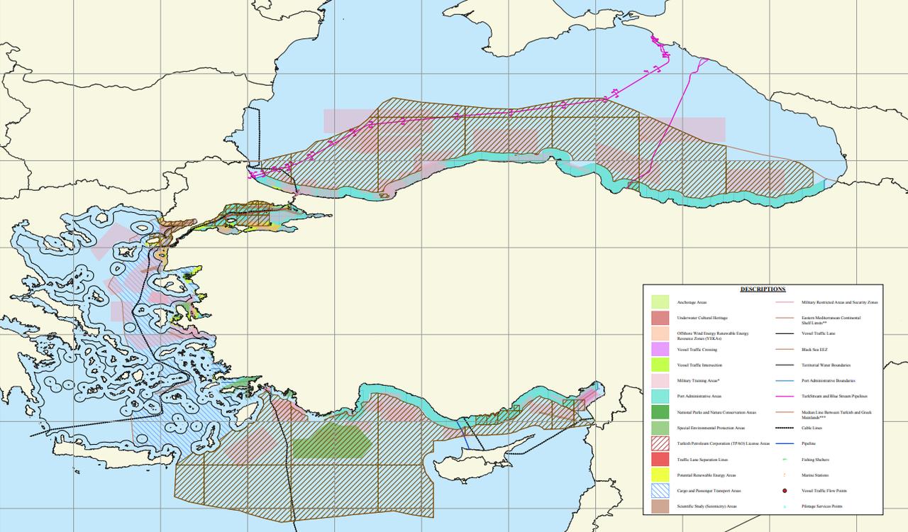


Türkiye has officially registered its Marine Spatial Planning (MSP) Map─known as the "Blue Homeland" map─with the Intergovernmental Oceanographic Commission (IOC) of UNESCO, opening a new chapter in the country's maritime governance.
Coordinated by Ankara University’s National Center for the Sea and Maritime Law (DEHUKAM) and supported by numerous governmental bodies, the map outlines how Türkiye aims to manage its seas and coastal areas sustainably.
With the completion of the registration process, the map has now been published on the MSPglobal platform—an international initiative co-managed by the European Commission’s DG MARE and UNESCO-IOC. This move grants Türkiye’s maritime planning official visibility on a global scale.
The MSP Map, which was first made public on April 16, outlines designated zones for different uses in Türkiye’s surrounding seas. These include ecological protection areas, shipping routes, fishing zones, and areas for energy exploration. Marine Spatial Planning is a tool widely encouraged by the United Nations to help coastal states reduce conflicts, protect marine ecosystems, and support the blue economy.
Mustafa Baskara, director of DEHUKAM, emphasized the significance of this step, stating that the international registration demonstrates Türkiye’s commitment to its maritime resources and the broader “Blue Homeland” doctrine. He noted, “This is a cornerstone in shaping the way forward. From now on, all efforts around Türkiye’s marine spatial planning will move with greater momentum.”
Marine Spatial Planning is coordinated globally under UNESCO’s IOC, which oversees how countries map out their marine and coastal zones to balance environmental and economic priorities. Over 70 nations are involved in the MSPglobal roadmap that was launched in 2017, and Türkiye's participation marks its strategic alignment with this international framework.
Baskara highlighted that the process started soon after the map’s public launch in April. Türkiye's ministry took swift action to submit the document to UNESCO. Now that the map is live on the MSPglobal platform, it affirms that Türkiye is actively managing its maritime zones with sustainability and international cooperation in mind.

The map’s registration did not go unnoticed in the region. Greece's Ministry of Foreign Affairs issued a statement criticizing the map’s publication, calling it a reaction to Athens’ own marine planning efforts, which it claims are already integrated into European Union legislation.
According to Protothema, the Greek ministry asserted that the Turkish map holds “no basis in international law” and “has no legal effect.” It described Türkiye’s move as “a reflexive reaction of no substance,” suggesting that it aimed more at domestic audiences than international diplomacy.
Despite the criticism, DEHUKAM Director Baskara dismissed such statements. “Declarations from Greece will in no way affect the legitimacy or value of this map. Türkiye has upheld its maritime rights in line with international law since the 1970s, and this map reflects that long-standing legal foundation.”
He further stated, “This is a qualified map, based on scientific data, and structured around multi-sectoral activity zones. Unlike what was announced by Greece, this is not a symbolic gesture but a plan rooted in science and law.”
According to accompanying documents on the MSPglobal site, Türkiye acknowledged that formal exclusive economic zone (EEZ) agreements are currently in place only in the Black Sea. The country referred to ongoing disputes with Greece in the Aegean and noted that the current planning is based on median lines pending any future bilateral agreement.
The Turkish platform text—now visible via the UNESCO-hosted website—also includes legal references to agreements with Libya and the Turkish Republic of Northern Cyprus (TRNC), while noting unresolved maritime delimitation issues with Syria. These details appear to emphasize Türkiye's broader legal positioning over its regional maritime jurisdiction.
The platform further invokes the 1976 International Court of Justice decision on the Aegean continental shelf, suggesting that Türkiye’s maritime claims rest on areas considered "under dispute" by the court. It adds that “no maritime borders between the two countries have been finalized” and that “fair resolution based on equality in line with international jurisprudence” is needed.
Baskara concluded that the map, now officially recognized, demonstrates Türkiye’s comprehensive and science-driven approach to managing its seas. "This milestone shows that Türkiye is actively shaping a sustainable and legally grounded maritime future.”


 2 min read