Newsletters


The European Commission, as part of its Maritime Spatial Planning (MSP) initiative, has published official maps on its website that exclude Türkiye from the Aegean and Eastern Mediterranean regions.
These maps, which outline the maritime areas of EU member states, have sparked attention due to Türkiye's absence from key areas.
The MSP Platform, funded by the European Union and operating under the European Commission, has conducted a study outlining the maritime boundaries of EU member states. The initiative aims to define the boundaries of European seas, promoting more efficient, secure, and sustainable activities in these maritime regions.
The Intergovernmental Oceanographic Commission (IOC) defines Maritime Spatial Planning (MSP) as a process through which maritime areas are determined via "a political process." It emphasizes that MSP is "not a goal in itself," but rather "a practical way" to manage and organize maritime space effectively.
As part of this initiative, the European Commission requested EU member states to submit their Maritime Spatial Planning studies by 2021. However, some countries have yet to submit their plans.
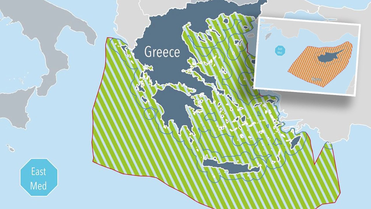
Although Greece has not officially adopted a Maritime Spatial Planning (MSP) framework, it has submitted some of its work to the European Commission. The most recent Greek plans, updated and reviewed by the Commission in April 2024, have been added to the official website. However, the map displayed on the site contains contentious information regarding maritime boundaries.
The maritime jurisdiction map for Greece, published by the European Commission, not only claims the entire Aegean Sea for Greece but also overlaps with Türkiye's territorial claims in the Eastern Mediterranean, effectively confining Türkiye to the Gulf of Antalya.
Although the map states, "Greece's territorial waters extend up to 6 nautical miles and cover an area of approximately 92,095 square kilometers," it is evident that the map has been drawn according to the 12-nautical-mile rule, granting extensive maritime zones to islands on the opposite side, with the median line drawn using islands as reference points instead of the mainland.
This has resulted in the transfer of sovereignty over islands, islets, and rocks to Athens, even those not formally ceded to Greece. Notably, the island of Meis (Kastellorizo) has been granted over 40,000 square kilometers of maritime space.

The international agreements cited while drawing these alleged boundaries do not align with the facts. The document includes the following information regarding the agreements that determine the boundaries:
However, the Turkish-Italian Technical Record of Dec. 28, 1932, cited in the document was never signed, ratified in parliaments, or enacted into law.
Furthermore, the European Commission's website also features a map showing the so-called maritime areas of the Greek Cypriot administration.
In the document, which states that the work regarding Cyprus has been completed, it is noted: "The internal waters and territorial waters of Cyprus extend over an area of approximately 13,968 km² up to 12 nautical miles. The Exclusive Economic Zone (EEZ) of Cyprus is approximately 98,240 km²."
The document disregards the equal rights of Turkish Cypriots on the island, while also encroaching on maritime zones of Türkiye, Syria, Lebanon, Israel, Palestine, and Egypt. It is claimed that all these boundaries are in accordance with the 1982 United Nations Convention on the Law of the Sea (UNCLOS).


 10 min read